[Photo courtesy of Betty Blade/Flickr]
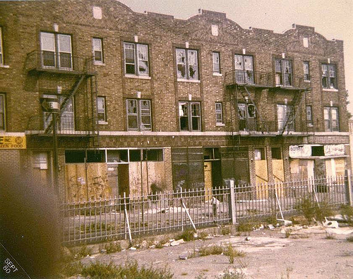
This is McDonald Avenue near Avenue C in Kensington in 1980. The photographer writes: “This is where the F train begins its rise to become an elevated train going out to Coney Island. I have to apoligize for my finger but I remember how nervous I was taking this picture with my new camera. I just got it and didn’t want to get ripped off. Funny thinking back … I was only 1 block from home and I felt so far away.” It all feels very, very far away.

7 responses so far ↓
1 BrooklynBorn // Jan 16, 2009 at 8:45 pm
wow I recognized that immediately. My mom and I would take the bus from Prospect Heights (which we then referred to as Crown Heights) and trek to the last stop at Cortelyou Road (it was the B69, which no longer goes out that far) We lived on East 3rd Street between Avenue C and Cortealou Road and I went school on Avenue C, PS 179.
I have great memories of a neighborhood that was working class Irish, Italian, Jewish, Puerto Rican, Black, Russian and Middle Eastern (in that order as I recall) The blocks were single family home lined and warm, but yeh McDonald avenue especially on that block was a no-man’s land.
I think I was warned not to go there but there wasn’t a specific menace, there just was nothing there. Also the old Fort Hamilton Line tracks were still standing, that entire area leading away from McDonald Ave was spooky in a slightly fun mysterious way. Thanks for the reminder.
2 BrooklynBorn // Jan 16, 2009 at 8:47 pm
Btw I never could spell “Cortelyou”.
3 Dan // Jan 17, 2009 at 1:32 am
According to Google Maps, this building now houses a preschool, Pediatrician’s offices, and a Pakistani restaurant. I love this city.
4 Prodigalson // Jan 17, 2009 at 9:37 pm
I used to pass by that scene every day. Does anyone have a current day photo of that area?
BROOKLYN IS GOD’S COUNTRY!
5 matt // Jan 18, 2009 at 10:05 pm
http://maps.google.com/maps?f=q&source=s_q&hl=en&q=40.640123,+-73.978865&mrt=all&jsv=141e&sll=40.640123,-73.978865&sspn=0.011984,0.027895&ie=UTF8&geocode=FXsebAIdDyyX-w&split=0
click on the streetview icon (the yellow man in the upper left corner)
6 Jon // Jan 20, 2009 at 1:47 pm
Yeah I live on that block and have some photos of what it looks like now. I’ll post them when I get home tonite.
It’s actually a thriving place these days. It’s mostly a Bangladeshi community now, with some Latinos mixed in, and with the restaurants and hair salons up on the Church end of the block and a mosque on the Ave. C end, there is a lot of traffic back and forth and just a very busy sense about the place.
7 Comestiblog // Jan 23, 2009 at 12:41 pm
If memory serves me correctly, prostitutes used to work the streets here while kids were walking to P.S. 179.