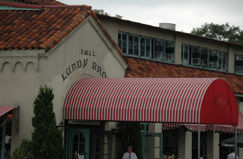
O.L. Robau, who produces Kinetic Carnival, which is devoted to Coney Island and is one of our favorite blogs, reports that Sheepshead Bay landmark Lundy’s is no more. He left the news as a comment on an item, and we wanted to highlight the information. Mr. Robeau writes:
Lundy’s restaurant has been shut down.
According to the Greek owners of Lundy’s, they have been locked out and evicted. Apparently they have not payed their rent in almost a year and the landlord got their court order to evict them. The owners came to the restaurant last weekend to find the locks changed. There are rumors that Outback Steakhouse is interested in the space. Regardless of what the location turns into, Lundy’s restaurant as well as the building is a landmark. Therefore, at least, the menu must contain lobster and a raw bar.
Lundy’s, which is on Emmon’s Avenue, opened in Sheepshead Bay in 1907. At the time, it was on the bay side of Emmons, on pilings in the water. It opened at the present site (which is the northwest corner of Emmons and Ocean Avenue) in 1938. It could serve 2,800 people at a seating. Lundy’s closed in 1979 and reopened in 1995. There had been rumors of another demise.
January 19th, 2007 · Comments Off on Preservationists Push Domino Sugar Plant Online Landmark Petition
We linked to this item from the Historic Districts Council Blog yesterday, but it’s worth noting in a bigger post. The Waterfront Preservation Alliance of Greenpoint & Williamsburg has had an petition online for some time calling for the historic Domino Plant on Kent Avenue to be landmarked. Lanmarking would be significant, as the parcel will likely be rezoned for residential use. It was not included in the big waterfront rezoning that is producing highrises on Kent Avenue, but plans call for up to four towers of 40 stories each on the site. If you think the historic buildings on the grounds should be landmarked, head over to the petition and sign up.
January 18th, 2007 · Comments Off on Filling Out the Coney Island Vision
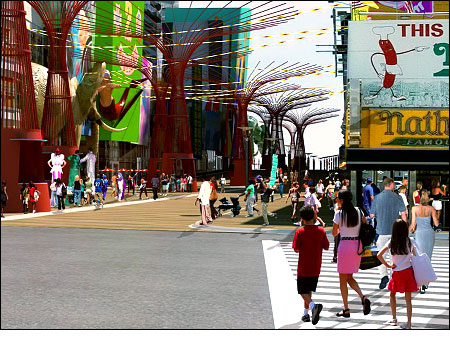
Yesterday, in his State of the City Address, Mayor Bloomberg mentioned Coney Island as one of the parts of New York City that will be rezoned to promote new development. We’ve been following the blow-by-blow of various Coney land deals, renderings and ideas, and the Daily News website today posts an article by Jotham Sederstrom that appeared in print a few days ago. It has some interesting information:
In addition to hundreds of upscale housing units, big-name franchises like Nickelodeon, W Hotel and the House of Blues are being floated as possible components of the revitalization plan, sources familiar with some of the proposals have said.
Add to that a slew of entertainment attractions – including a state-of-the-art roller coaster designed to wind around buildings on Stillwell Ave. – and Coney Island could begin to resemble a Las Vegas on the Atlantic Ocean.
But until the 13-member Coney Island Development Corp. releases its long-awaited master plan, nothing but sand and water is certain for the neighborhood.
“You should have a big question mark over the whole thing,” said Community Board 13 District Manager Chuck Reichenthal. “One doesn’t know from day to day.”
There’s a lot of interesting detail in the article and also an interesting map that goes with the story that we are reposting below.
Comments Off on Filling Out the Coney Island VisionTags:coney island
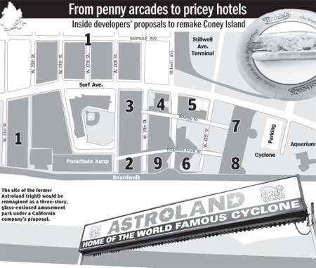
For those that have been having a hard time seeing what might go where in the new Coney Island, an article in the Daily News by Jotham Sederstrom has a map and text that lay out the possible new configuation and projects. Here’s the key to the map:
1. New York-based Taconic Investment Partners hopes to build residential and retail on 100,000 square feet of land on four parcels between W. 16th and 20th Sts. between Mermaid and Surf Aves. Taconic also plans:
* Residential and retail space on 180,000 square feet of land between Surf Ave. and the Boardwalk at W. 21st St.
* Child’s Restaurant site is being eyed for a high-end catering hall between Surf Ave. and the Boardwalk at W. 21st St.
* Residential and retail space on 18,000 square feet between Surf Ave. and the Boardwalk at W. 22nd St.
2. A proposed new street, tentatively called Front St., to be built from the Parachute Jump to the Cyclone, spanning roughly 2,400 feet and used primarily as a pedestrian throughway.
3. Bowery St., currently composed of penny arcades, fast food restaurants and small rides, could turn into five blocks of retail and restaurants. Along W. 15th and 16th Sts., however, developer Horace Bullard still owns property and hasn’t said publicly what he plans to do with it.
4. Stillwell Ave. south of Surf Ave. would become “Stillwell Walk” and serve as the main thoroughfare of Coney Island, with open-air cafes and retail along a cobblestone street. A 4,000-foot rollercoaster designed by Switzerland-based Intamin AG is also in the works.
5. Called “Splash,” this 150-foot observation deck with holographic displays, light shows and water mist, would be the first thing people see upon exiting the Stillwell Ave. subway station. A rooftop beer garden, with views of Brooklyn and the Atlantic Ocean, is also in the works.
6. Anchored by one of two planned hotels, this 75,000- square-foot glass-encased water park would soar eight stories and sit atop a parking garage.
W Hotel and Nickelodeon, among other hoteliers, are in talks, sources said.
7. The second of two hotels planned for Coney Island would sit above an entertainment attraction, which sources said could be a live music venue.
A source close to House of Blues said the franchise was looking seriously at expanding to New York.
8. The former Astroland amusement park would be reimagined as another park, this one glass-enclosed and potentially three stories tall. The Burbank-based Thinkwell Design and Production is currently designing amusement rides.
9. Developer Thor Equities plans to build residential near the Boardwalk between W. 15th St. and Stillwell Walk.
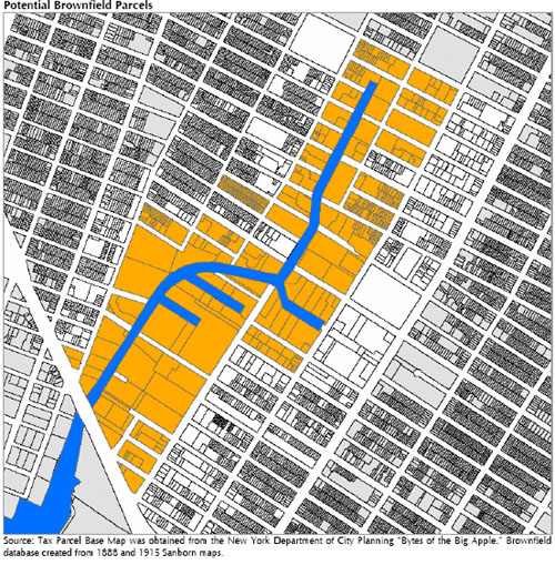
What’s under Gowanus? A little bit of everything, apparently, given the neighborhood’s industrial lineage dating to the 19th Century. Among the many things contained in the 161-page Gowanus Comprehensive Plan is a sobering look at the environmental challenges in and around the Big G. The map above shows possible brownfield sites in the neighborhood based on their former industrial uses. (In other words, virtually every bit of land around the canal, and the historical survey used to create the map only covered land within a block or so of the canal.)
The neighborhood, for instance, had three Manufactured Gas Plants, which introduced a toxic soup of byproducts into the environment, including cyanide. The Thomas Greene Playground is part of one of the former Manufactured Gas Plant sites. The plan says, “the consultant does not have any information regarding potential community exposure” and recommends working with Parks Department “to determine if any community health risks do exist at this playground.”
Of the former Brooklyn Rapid Transit Authority Power Plant that is part of the “Gowanus Village” site, the report says:
The former power station may still contain asbestos-containing material within its insulation and PCB oil within the remaining electrical equipment. The station was powered with coal, which may have resulted in coal tar impacts in the soil and groundwater. The property to the south contained several coal yards and a sulfur works, which are additional potential sources of contamination. To the north lies the filled-in First Street Turning Basin and stretch of bulkhead that has completely failed. Nothing for certain is known about when or with what the turning basin was filled in. In short, there are enough potential sources of concern at this site that the GCCDC should work closely with the site developer to ensure that any environmental impacts that are found are adequately addressed.
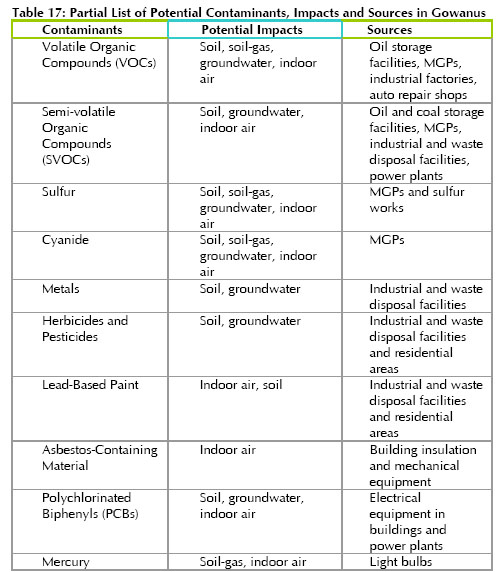
The table below shows some of the substances beneath Gowanus and their sources.
January 18th, 2007 · Comments Off on The Ground Beneath Gowanus, Whole Foods Edition
While much of attention recently has been focused on the benzene in and around the future site of the Whole Foods in Gowanus, the site itself has an interesting past. The Department of Environmental Conservation’s website notes “subsurface soils and groundwater are contaminated with volatile organic compounds, semi volatile organic compounds, and chlorinated solvents.” Among the substances disposed at the site were napthalene and xylene. Meantime, Stephen Witt relates some details about the site’s past (it was originally a wetland) and present from a recent DEC fact sheet in the latest Courier-Life papers:
The site was created by filling the wetlands during the mid-1800s and the early 1990s and specific sources of fill material are unknown, according to the fact sheet.
However, according to the United States Army Corps of Engineers, the canal is filled with 20 feet of ash in some places and it was a common practice to use demolition debris, ash and furnace slag as riverfront fill.
During the late 1800s through 2004, the site was the location of numerous industrial operations, including coal yards, an ice company, lumberyards, a petroleum oil company, a building materials company, a trucking company, a freight depot, and an automobile junkyard and automobile repair shop.
Contamination related to these former industrial operations included the BTEX compounds benzene, toluene, ethylbenzene, and xylenes.
These are volatile organic hydrocarbons found in most petroleum products such as gasoline, according to the DEC fact sheet.
We scoured the DEC website, but the fact sheet does not appear to be posted online, unless we somehow missed it.
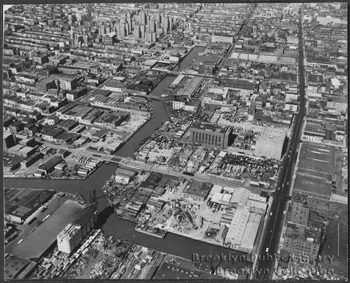
January 18th, 2007 · Comments Off on Gowanus Back in the Day
Here’s another one from our Gowanus Back in the Day feature of historic photos. Like many others, this is from the Brooklyn Public Library‘s extensive collection of historic Brooklyn pics. It’s simply dated as “1950s” and is an aerial showing the bridges over the Gowanus. Look closely and you can see some landmarks that still exist and see what used to stand in place of what’s there now.
Comments Off on Gowanus Back in the DayTags:Uncategorized
The Gowanus Canal CDC has released its final plan for Gowanus. The news comes via a release from the CDC and its chair Michael Ingui. The final plan is posted on the CDC’s website. (We are not posting a direct link to the PDF because it is big and can virtually freeze your computer depending on your connection. Release of the plan is also reported by Brownstoner.) It divides the neighborhood into North and South “zones,” each of which would feature a different mix of uses. Overall, the plan pushes a “green” focus for new development and industry. There is also a development on the Gowanus Canal Conservancy front. The group was formed this summer to help advocate for improving the environmental quality of the canal and for making it more friendly to recreational uses. The group wants to create a Gowanus Canal Environmental Education Center on the Big G with classroom and meeting space, an auditorium, office space for Gowanus-related groups and a boat launch. The plan, “includes the concept of the ‘canal as park’ – viewing the waterway, like a park, as a precious community resource for all users, industrial and residential, to be improved and protected.” The group is apparently looking at the creation of a “Canal Improvement District.”
We will dive into the plan a bit more in coming days, but for now, it’s worth pointing out that the it is an independent vision of Gowanus’ future. The city is just beginning its planning effort for the neighborhood that will serve as the basis for a comprehensive rezoning. Developers have already expressed frustration that the process is moving slower than they would have hoped.
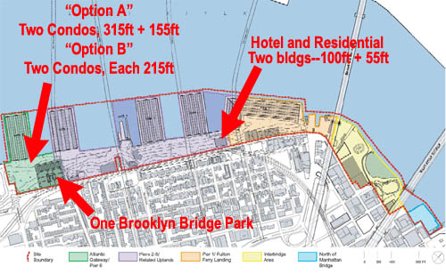
January 17th, 2007 · Comments Off on Brooklyn Bridge Park, Part III: Where the Tall Buildings Will Go
So where would the development that will be used to pay for the park elements of the waterfront “civic and land use project” known as Brooklyn Bridge Park go? We concocted the above map to show the approximate location of the mixed-use hotel-residential complex (with up to 225 hotel rooms and 150 condos) that would go near Pier 1 where the old storage building is currently located, as well as the big highrises that would go in the “uplands” of Pier Six, more or less near the foot of Atlantic Avenue. None of this, of course, is news and the project plan has already been approved, but virtually all of the beautiful renderings of the park have studiously avoided including drawings of the high rises. So, it’s always interesting to have a look.
There are two main condo options according to revised plan issued by the Empire State Development Corp. Option One includes a building 315 feet in height with up to 290 condo and a building of 155 feet with up to 140 condos. Option Two includes two buildings of 215 feet, each with 190 units. There would also be a 170-foot building with 130 units north of the Manhattan Bridge.
You can check out the entire revised plan here at the Empire State Development Corp.’s website. Just click on “Modified General Project Plan” in the upper right hand corner for the PDF.
January 17th, 2007 · Comments Off on More on the Broken Angel Condo Deal
Today’s Daily News fills in more details about the story we reported yesterday about Broken Angel’s future as condos, courtesy of developer Shahn Andersen. Creator Arthur Wood says he rejected offers of up to $1.8 million that would have destroyed the unique work of art he has created over time. Here’s an excerpt from the story:
“It will be taller, more majestic. We may even light it up at night, and it will be nicer,” Wood, 75, said yesterday.
He rejected offers of as much as $1.8 million that would have destroyed the 108-foot building in favor of one that will preserve it, he said.
He may even lose money, depending on how the condos sell, he added.
“It was tempting to take the money and leave, but I couldn’t do that,” Wood said. “The building is a living entity, and I wasn’t about to abandon it.”
Local developer Shahn Andersen agreed Saturday to buy a 50% stake in the structure, financing the rebuilding of Wood’s creation with potential profits from condos.
While have concerns about a condo project, we’re also realists about how things must be financed in an era whent the public sector is unwilling to help (and, in this case, has acted as the problem, rather than the solution.) We trust the team of Andersen & Wood will create a true Brooklyn landmark.
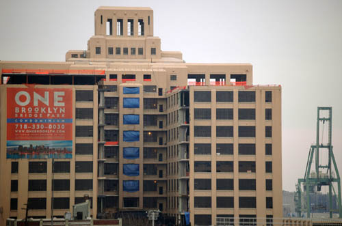
January 17th, 2007 · Comments Off on Brooklyn Bridge Park, Part II: The Sweetheart Deal Building
In case you were wondering what building yesterday’s Post story was talking about in discussing the “development team with close ties to ex-Gov. George Pataki” that “stands to rack up nearly $700 million in gross revenue by selling more than 400 luxury condos to be built within the state-planned Brooklyn Bridge Park,” that’s it above. The development is the flashy One Brooklyn Bridge Park which is being built by developer Robert Levine and some partners. According to the Empire State Development Corp., sales at the complex will reach $674 million, with one study estimating profits of $365 million. The developer told the Post the profit on the 441 luxury units at One Brooklyn Bridge Park would be one-third that figure. What is even more interesting than the profit, though, is the developer’s relationship to the just-departed Pataki Administration. Says the Post:
“It looks more and more like a risk-free deal written by Robert Levine that the ESDC just went along with it,” said Cobble Hill activist Roy Sloane.
Levine’s partners include Thomas J. Murphy, a Pataki ally and former executive director of the state Dormitory Authority, and AIG Insurance, which records show donated $120,000 to Pataki from 2000 through 2004.
By going through the ESDC, the developer is circumventing city zoning. The controversial residential component of the development is being used to finance the waterfront park component. Fun reading in its entirety, esxpecially once you attach the building to the story.
January 17th, 2007 · Comments Off on Meet Your Department of Buildings. Or Not.
We would be riveted enough by the spectacle of the development site at 406-408 15th Street 9and Eighth Avenue) in the South Slope that threatens to undermine a variety of properties in the neighborhood, but we are utterly fascinated by the bureaucratic incompetence, malfeasance and nonfeasance surrounding it. The damage has been going on since last summer, to the point where buildings are cracking and becoming structurally unsafe, trees are falling over and sinkholes are opening. In a rational world, IMBY’s latest post would have city bureaucrats falling over each other to try to remedy the situation or to at least make it look they care. Here goes:
Let’s face it, the DoB is failing miserably in regards to protecting the surrounding properties… maybe as a morale booster if the DoB required its inspectors to wear one piece spandex blue and gold unitards, capes with the NYC BUILDINGS logo, and shiny black patent leather utility belts with matching boots… at the least they would still have some self esteem left to lose. I know what your thinking. You need to rotate inspectors to prevent the possibility of malfeasance and bribery. Hell, the way things are leaning in the contractors favor at 406, I would be truly disappointed if we find out no one has been receiving gratuities. Wow, free favors, that would really mean they don’t know their underpinnings from a hole in the ground…
So we had a steady tsunami of DoB inspectors out to look at the new damage. Are two inspectors in one week considered a tsunami? Two different inspectors among a half dozen who have made visits this far. One who admitted this isn’t his “area” and another who mysteriously disappeared after 5 minutes.
Unfortunately they had to be dragged kicking and screaming before they would come out to take a peek. Special thanks to Sergeant Ward at the 72nd police precinct for your help. Sergeant Ward had been out to the site to assess the damage months ago after a 5 foot deep sink hole formed taking out a utility pole and a tree. In his most recent visit, he immediately saw how bad the situation had deteriorated since his last visit and immediately made a call to the DoB.
That’s right… The police are now calling the DoB telling them they better get their asses over to the building site or else.
One wonders when the city will stop turning a blind eye to the awfulness on 15th Street and do its job to protect residents.
Comments Off on Meet Your Department of Buildings. Or Not.Tags:Uncategorized
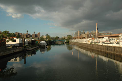
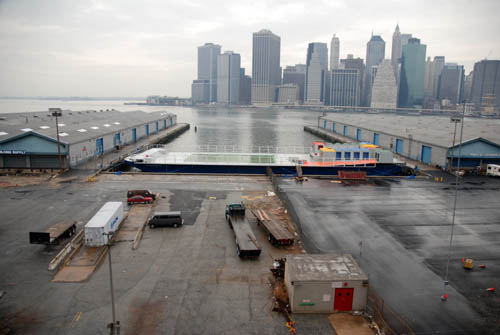
January 17th, 2007 · Comments Off on Brooklyn Bridge Park, Part I: The Barge Pool at Rest
The colorful little barge above docked at Pier 2 on the site of the future development called Brooklyn Bridge Park is the Barge Pool. It’s the Neptune Foundation‘s pool on a barge that will serve as a city park this summer. No word on the location(s) at which it will be docked, but it certainly promises to be one of the city’s more unique swimming experiences.
Comments Off on Brooklyn Bridge Park, Part I: The Barge Pool at RestTags:Uncategorized
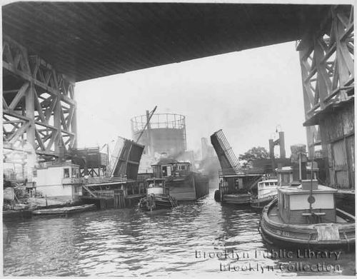
We revive our Gowanus Back in the Day feature of historic photos of the Big G with this excellent old black and white that has been lurking on our hard drive. The photo is from the Brooklyn Public Library‘s extensive collection of historic Brooklyn pics. The photo would have been taken, more or less, from the location of what is now Lowe’s. The description reads, “Gowanus canal at 9th Street drawbridge beneath elevated bridge or highway; two tugboats in right foreground; two men observing canal traffic from booth and platform at left; girders supporting elevated bridge at right and left; large water tank in background.” And, the caption says, “Up-sa-daisy — Ninth St. drawbridge reluctantly opens its jaws to allow one of the Gowanus Towing Company’s tiny tugs, the Victorious, to drag its giant-size barge through the Canal. Many of the Gowanus tug admirals have seen half a century wreak its changes along the Canal. The company has only four tugs now in active service, including the wonderfully named Hesperus.” Ah, the old days.
January 17th, 2007 · Comments Off on Brooklyn Reading Works, Thursday Night
The next installment of Brooklyn Reading Works, the series held at the Old Stone House between Third and Fourth Streets and Fourth and Fifth Avenues, features Adarro Minton, the author of the short story collection Gay, Black, Crippled, Fat. He’ll be reading on January 18 at 8PM, and admission is $5. A short excerpt from the intro, to give you the flavor of this provocative work:
I have been expelled from St Peter Claver, St Catherine of Siena, and The Union Springs Academy, a Seventh Day Adventist boarding school, after refusing to submit to a weekly shower game that five lusty upper-classmen came up with. I survived the disco era in New York City, in imagined opulent splendor at Studio 54, Better Days, The Nickel Bar, 220 Club, The Saint, The Mineshaft, and The Paradise Garage. I survived mescaline, blotter acid, cocaine, freebase cocaine, crack, danger sex in subway bathrooms, hunger, homelessness, and three serious suicide attempts. In 1999, I lost the use of my arms and legs to a mysterious, and still undiagnosed form of myositis. Thanks to 12 steps, and the love of K.D. Haynes, I got up (so to speak) off of my clinically depressed ass, and in the year 2000, I began to forage through a lifetime of stories circling my soul. This collection represents the first set of them.
Excellent stuff.
Comments Off on Brooklyn Reading Works, Thursday NightTags:Uncategorized
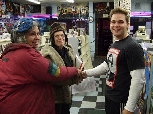
It’s official, the Clinton Hill landmark, Broken Angel, has been sold and will be developed as condos. Creator Arthur Wood will work to design the new development. The move toward a sale had been reported over the last two weeks. The new figure in the Broken Angel saga is Shahn Andersen (although an email from Chris Wood that arrived at midnight refers to him as “Shaun” Andersen). An empty lot next door will also be developed as “arts space.” Mr. Wood says he feels it is the “best opportunity” to work on the design and keep the “spirit and details of Broken Angel intact.” We assume that is Mr. Andersen with Mr. and Ms. Wood in the photo from onebadapple above. Here is the full text of Mr. Wood’s statement:
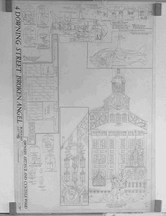
My parents signed an agreement with Shaun Andersen, a local developer on Saturday. This agreement will remove the threat of demolition by the Department of Buildings. Our thanks to Letitia James, Brent Porter, Peter Grossman and Zerlize Goodman for their help in overseeing and mediating the agreement. Under the terms of the agreement my father will work with Shaun to redesign and develop Broken Angel as condominiums. The sale of these condominiumswill pay for the work that is necessary to bring the building to code and allow my father to see his vision realized and completed. In addition a second building will be created at 8 Downing Street (the lot next door) that will become an arts space. My father chose to work with Shaun because from their previous friendship, he felt that given the current circumstances, this collaboration would offer him the best opportunity to contribute to the design of the building and keep the spirit and details of Broken Angel intact. A show of photographs and my father’s plans for the original and the re-envisioned Broken Angel are currently on display at Higgens Hall at Pratt.
The reenvisioned Angel, a drawing of which appears above right, includes a rotating whale at the top and a “Sunflower House.” We truly hope the partnership goes well and that Broken Angel is indeed saved rather than turned into a brand name for yet another pricey development. Done right, it will become an even more significant Brooklyn landmark.
Clarification: Mr. Andersen, in a comment left below, writes “The property was not sold. Arthur Wood and I are going to work together to renovate Broken Angel and rebuild it taller and more elaborate than it is now.”
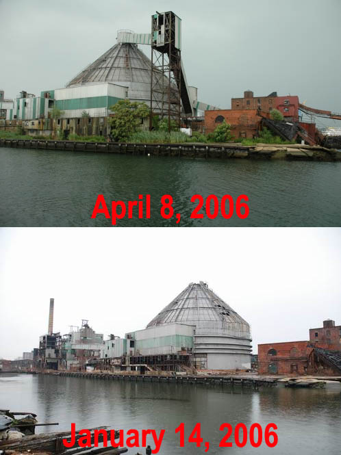
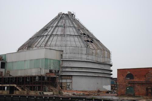
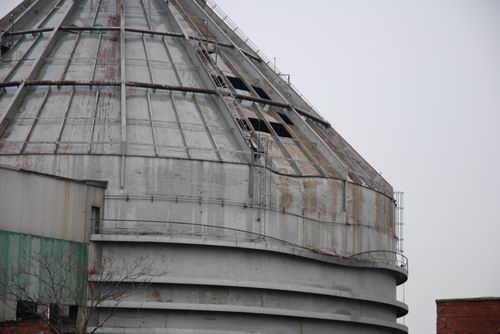
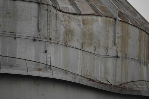
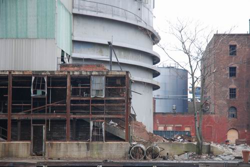
January 16th, 2007 · Comments Off on Revere Getting Banged Hard
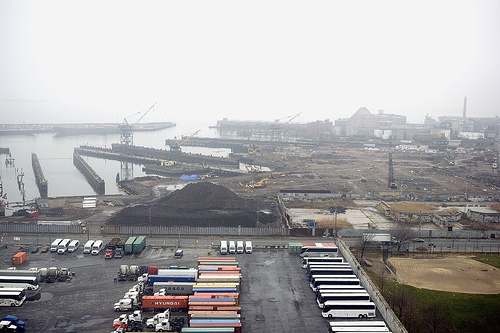
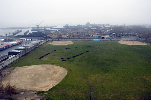
Red Hook’s old Revere Sugar Refinery does not have long to live. While the demolition work appears to have slowed on the front part of the structure, Thor Equities, Joe Sitt and Breeze Demolition have been busy tearing the Red Hook icon down from behind. There is now a gigantic dent in the dome, most likely where a tower fell into it during demolition, and external structures are being demolished.
Comments Off on Revere Getting Banged HardTags:Uncategorized
Check out this rocking photo of Red Hook taken from the roof of the huge Grain Terminal by f.trainer and posted on his flickr page. Clearly, he was on the same photo expedition that resulted in the cool Bluejake post. The little pic we’re reproducing here–that shows the former Todd Shipyards site in all its Ikea construction glory with the Revere Dome beyond–doesn’t do it justice. Click over to see the pic full size and the entire bunch. Another excellent shot below.
January 16th, 2007 · Comments Off on South Slope Amateur Demolition Porn Videos
Check out the latest installment in the war between developers and residents on 22nd Street, this time with youtube videos of some night demolition activity. This specimen comes from 338 22nd Street, which is the subject of many ongoing complaints. You can click on the embed below for Part I. Click here for Part II and here for Part III.
Here’s some narrative from a letter that went from Concerned Citizens of Greenwood Heights to the Department of Buildings:
Returning home yesterday, we drove by 338 22nd St. What we witnessed was a full asbestos removal crew, improperly abating the rooftop of 338 22nd St. on a Sunday. According to neighbors who live across the street from the site, the work began promptly at 9:00 am that Sunday morning and was still going on as we passed at 4:30 pm. It continued until past 7:00pm when we assume the Department of Environmental Protection inspector’s second visit shut the site down.
Gotta’ love the ability to post the problem on youtube.
Comments Off on South Slope Amateur Demolition Porn VideosTags:Uncategorized
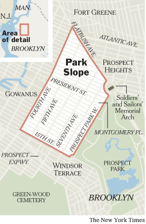
We’ve been known to say an unkind thing or two about the New York Times’ coverage of Brooklyn, most of it having to do with the way the most important paper in the nation covers our borough infrequently and incompletely. A lot of Brooklyn news, unfortunately, does not appear fit to print. In any case, the Times ran an article about Park Slope in the Real Estate Section and a reader emailed us to note that the paper ran a map that actually got the neighborhood’s borders right, by 2000s standards. Meaning that it doesn’t try to usurp any of Gowanus or Sunset Park. (We wouldn’t have looked at the map on our own, as we know where Park Slope is, so we thank the eagle-eyed GL reader for pointing it out.) In any case, here are few words from the article about Fourth Avenue:
These days it’s also a construction zone, at least on its fringes. Developers have worked quickly since 2003 zoning changes along Fourth Avenue, Park Slope’s noisy, truck-filled western border with Gowanus, to begin building condominium towers and a hotel there. Comparisons to a new Park Avenue for Brooklyn are being made, with occasional snickers, on local blogs. But building presses on, with sales soon to begin at the Novo Park Slope, a wide 12-story condo building at Fifth Street. The construction is “very quickly transforming Fourth Avenue from what was otherwise a forlorn, neglected thoroughfare into a place where people can live,” said Craig Hammerman, district manager for Community Board Six. “Whether or not the infrastructure is there to support it is now the newest challenge.”
We now return to our regular programming, grousing about how the Times is more likely to report on a Brooklyn stabbing than an important development or public policy issue issue.

 favorite blogs, reports that Sheepshead Bay landmark Lundy’s is no more. He left the news as a comment on an item, and we wanted to highlight the information. Mr. Robeau writes: